 New York-New Jersey Trail Conference
Highlands Trail/Pine Swamp Trail/Ogden Mine Railbed Loop
Directions to trailhead
Take I-80 to Exit 34B. Proceed north for 5.0 miles on N.J. Route 15, and get off at the exit for Weldon Road and Milton. After about 1.3 miles on Weldon Road, you will pass a sign marking the entrance to the Saffin-Rock Rill area of Mahlon Dickerson Reservation. Continue for another 1.5 miles (2.8 miles from Route 15) and turn right into the Saffin Pond parking area.
Hike Description
On the southeast side of the parking area, you will notice a triple black-diamond-on-teal blaze, marking the start of a connector trail to the Highlands Trail. Follow the black-diamond-on-teal blazes, which head east along Saffin Pond. Several side trails on the right lead to viewpoints over the pond.
At the southeast corner of the pond, turn right and proceed along the dam. Before reaching the bridge over the outlet of the pond, bear sharply left onto a gravel path – the route of the teal-blazed Highlands Trail. Continue to follow the Highlands Trail as it ascends gradually along a woods road. At the top of the climb (marked by a bench), bear left at a T-intersection and continue to follow the teal diamond blazes along a woods road.
In a third of a mile, the Blue Trail joins from the right. Just ahead, the Blue Trail ends, and the Yellow Trail joins from the left. The joint Highlands/Yellow Trail continues ahead on the woods road.
In another 0.2 mile, the Highlands/Yellow Trail begins to descend. A short distance beyond, the trail bears right at a fork (the left fork is the Pink Dot Trail [black dot on pink], that leads to Weldon Road). The trail continues to descend until it crosses a wooden footbridge over a stream and ascends on a gravel road. In another 500 feet, the Highlands/Yellow Trail reaches a T-intersection and turns right. Then, in another 500 feet, the Highlands/Yellow Trail turns sharply right onto a grassy woods road (straight ahead, the Pink Trail follows the gravel road for 0.3 mile to another junction with the Highlands Trail).
In a quarter mile, in an open area, follow the Highlands Trail as it turns left, leaving the Yellow Trail. The Highlands Trail climbs gradually to reach a broad overlook to the southeast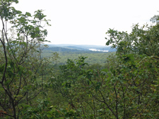 from a rock ledge to the right of the trail. Except for a few power line towers, no civilization is visible from here; you see only forested hillsides, with Lake Hopatcong visible in the distance to the right. After a slight dip, the trail climbs through a canopy of mountain laurel to reach another viewpoint. This viewpoint, marked by a bench and designated on the map as the Headley Overlook, is more popular because it is nearer the road, but the first overlook provides a less obstructed view.
Continue ahead on the Highlands Trail, which now descends on a woods road through more mountain laurel, and bear right at the next T-intersection. As the trail approaches Weldon Road, it bears right at a fork, then crosses the paved road and soon emerges onto a parking area.
Follow the teal diamond blazes of the Highlands Trail as they continue along a paved service road from the end of the parking area. The road heads through a picnic area. When the paving ends, proceed ahead on a gravel road, continuing to follow the teal blazes.
Soon, you’ll reach a T-intersection, which marks the start of the loop of the Pine Swamp Trail. Turn left, leaving the Highlands Trail, and follow the white blazes along a woods road. At a Y-intersection a short distance ahead, bear left, leaving the white-blazed trail, and follow the Red Trail ahead to a camping area.
When you reach an open field, bear left and follow along the left side of the field, then bear right onto a park road, passing a restroom building. Immediately bear left at the next fork, and follow the road for about 100 feet. Opposite Campsite #4, you’ll notice a sign pointing to the Pine Swamp Trail. Turn right here and follow the Red Trail into the woods.
In about a third of a mile, bear right at a fork. Just ahead, the white-blazed Pine Swamp Trail joins from the right. Bear left, now following both red and white blazes, but in 50 feet turn right, leaving the Red Trail, and continue on the white-blazed 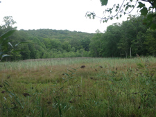 Pine Swamp Trail. The trail follows a winding woods road up to the highest point in Morris County (1,395 feet), marked by a bench to the left of the trail and (just beyond) a sign to its right.
The trail now descends to reach a junction in a hemlock forest. Bear sharply left here, leaving the white-blazed trail, and follow the Green Trail. To your right is the unusual Pine Swamp, with its tall spruce, hemlock, rhododendron and mountain laurel.
In another two-thirds of a mile – after a steady descent – you’ll reach a junction with the railbed of the Ogden Mine Railroad. Built in 1855 to transport the ore from local mines, it was abandoned in 1930. Turn left (still following the green blazes) and proceed south on this nearly-level railbed through rock cuts and over embankments. In about a third a mile, you’ll pass the start of the Red Trail on the left and (just beyond) a large wetland on the right. Then, in another 750 feet, you’ll pass a large wetland on the left. The hill visible (on the left) beyond the wetland is the one you climbed earlier in the hike to reach the highest point in Morris County. Continuing ahead, the railbed begins to parallel Weldon Brook on the left. After passing another large wetland (Toomey’s Pond) on the left, you’ll reach Weldon Road. The parking area where you began the hike is across the road to the left.